Insight for an Uncertain World
About the Aviation Safety Monitor
The Aviation Safety Monitor is a service provided by Robust Analytics to deliver timely information on terminal area safety in the National Airspace System (NAS). The safety monitoring and prediction technologies were developed by Robust Analytics over the past several years. Partial funding was provided by the NASA Small Business Innovation Research Program and the NASA System Wide Safety Project.
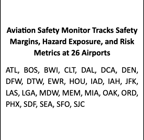
The Aviation Safety Monitor provides quantitative estimates of safety margins at 26 airports in 17 metropolitan regions in the United States. This information complements data on several safety-related events that are published elsewhere, with the FAA’s Runway Incursion Statistics website a good example. However, the available safety information can be misleading if it only reports the frequency of violations with no insight into how safety buffers may vary minute-to-minute and day-to-day. The Aviation Safety Monitor aims to provide this insight every week.
How Do We Measure Safety Margins?
The Aviation Safety Monitor summarizes output from Risk Tracker, the Robust Analytics in-time terminal airspace hazard and safety metrics monitoring system.
​
​
​
​
Welcome back to the Weekly Aviation Safety Report! We were extremely pleased with the reception to the previous posts and we plan to keep reporting in the coming months. Every Monday Robust Analytics reports on safety margins at 26 United States airports. With this Aviation Safety Monitor Weekly Report, Robust Analytics offers the aviation community timely assessments of changing safety margins and safety-related events. The first two postings introduced some of the metrics we use to track changes in safety margins in terminal airspace. This week, we provide an update to those data and introduce some new data displays. Dates and times are tracked in UTC and the week ends at midnight every Saturday. This week’s report includes data through 2400 UTC on April 20, 2024.
​
​
​
​
​
​
​
​
Please read our article “Did Safety Degrade in the National Airspace System in the Winter of 2022-2023?” that applies our methods and data to examine whether safety margins decreased during the events of winter 2022-2023.
The Aviation Safety Monitor measures safety margins by estimating the frequency, duration, and severity of buffer encroachments. Our paper “How Do We Measure Safety Margins?” provides a detailed description of the methods and data. That can be found here https://www.robust-analytics.com/measure on the Robust Analytics website.
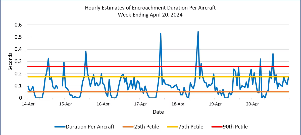
This week we add to the weekly charts by showing data on safety margins for different time periods: the most recent week, the past month, and the past two months. We begin by taking a closer look at safety margins for the seven days ending April 20. Figure 1 displays estimates of encroachment durations per aircraft for each hour over the seven days. This offers a more detailed look at how safety margins vary over the operating day. Figure 1 also indicates the typical range of the data by showing the 25th, 75th, and 90th percentile values of the duration per aircraft metric. The percentiles are calculated from 14 months of data from May 2022 through June 2023.
The estimates show a few high spikes early in the week, with most observations below the 75th percentile. Later in the week, however, there are higher spikes on the April 17 and 18 with values well above the 90thpercentile, and many hours with values above the 75th and 90th percentiles on April 19 and 20. All in all, the week ending April 20 was typical with no significant trends or data to draw concern.
​
​
​
​
​
​
​
​
​
​
​
​
Figure 1. Hourly Encroachment Duration Per Aircraft for the Week Ending April 20, 2024
​
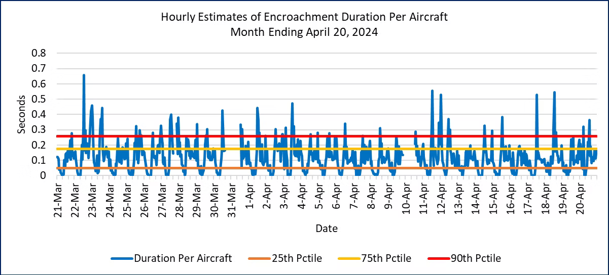
Examining monthly data allow us to look for trends over longer time periods. Figure 2 shows duration per aircraft for the month from March 21 through April 20, 2024. Occasional spikes in durations indicate short periods of reduced safety margins, but there is no obvious trend during this time period.
​
​
​
​
​
​
​
​
​
​
Figure 2. Hourly Encroachment Duration Per Aircraft for March 21 to April 20, 2024
​
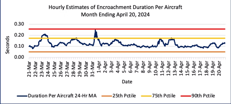
The hourly data display a predictable time of day pattern with durations dropping close to zero during overnight hours. That pattern also makes it harder to visually detect time trends, so we applied a 24-hour moving average to remove the within-day variation. Those moving averages are shown in Figure 3. They show a jump in durations around March 23 and March 31, with moderate increases for several days in the second week of April.
​
Figure 3. Moving Average Hourly Encroachment Duration Per Aircraft, March 21 to April 20, 2024
​
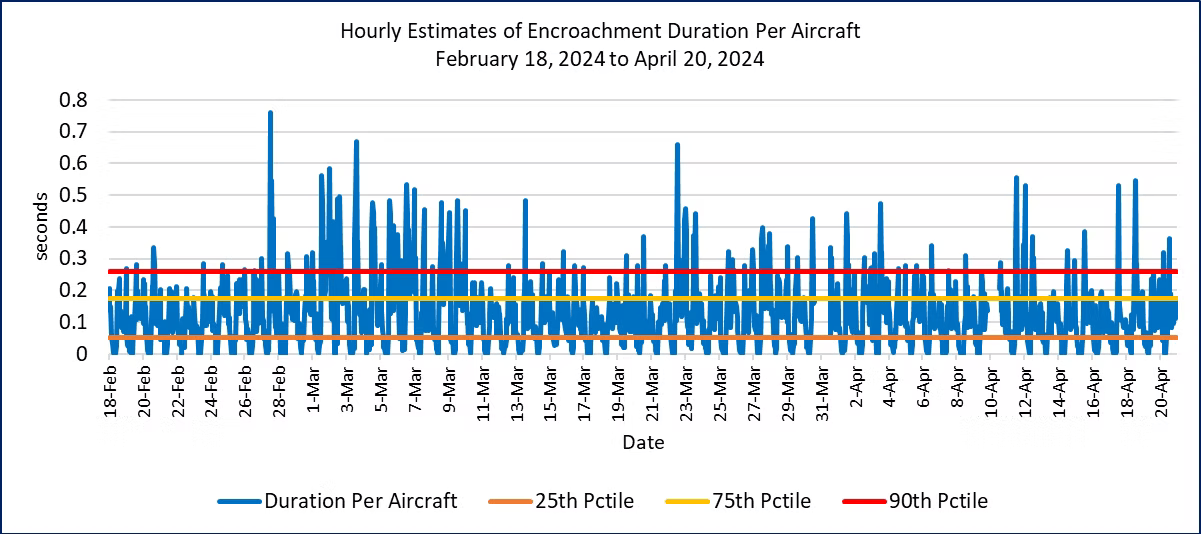
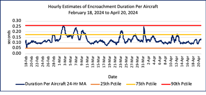
Figure 4 shows a longer perspective with data back to February 18, 2024. This chart clearly shows the reduced safety margins for several days in early March that we reported on in our initial posting on April 8, 2024. That early March period remains the highest and longest durations in the past two months, and well above the 90th percentile for many time hours.
​
Figure 4. Hourly Encroachment Duration Per Aircraft, February 18 to April 20, 2024
​
Figure 5 displays the moving average version for the past two months, highlights the early March increase in encroachment durations for more than a week. This is the only sustained period of more than a couple of days for the past two months.
Figure 5. Moving Average Hourly Encroachment Duration Per Aircraft, March 21 to April 20, 2024
​
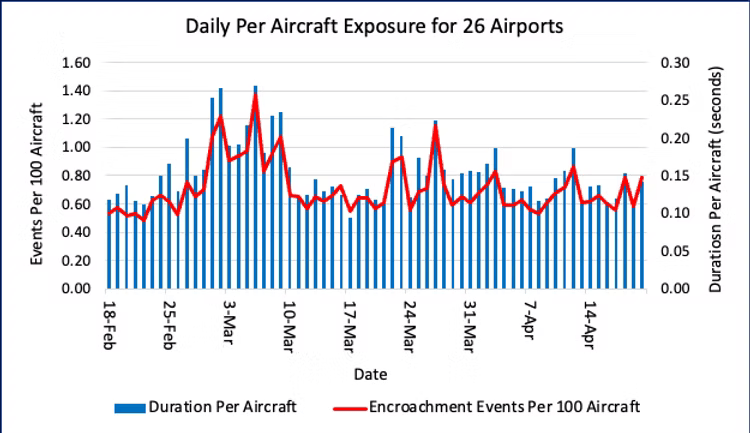
We wrap-up this week’s report with updates to the two charts presented in the previous weekly reports. Figure 6 shows the total daily counts of the number of encroachments and their durations across the 26 airports in the 17 metropolitan areas that we monitor. The blue bars report estimates of total daily encroachment durations divided by the number of aircraft in the terminal airspace (approximately 50 miles of the airport center) for all 17 terminal airspaces. The red line reports the daily number of encroachment events per 100 aircraft.
Figure 6. Encroachment Duration Per Aircraft and Event Rates for 26 Airports
(February 18, 2024 through April 20, 2024)
​
As data are added to the chart each week, readers can begin to detect some mild day-of-week variation and, more importantly, periods of a few days and even a week or longer in which encroachment durations increase significantly. In the coming weeks, we will examine these fluctuations in more detail.
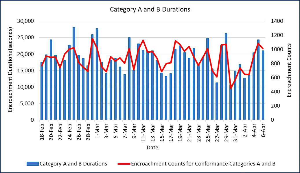
How severe are these encroachments? The FAA defines three separation conformance categories based on how far they are from the separation index. (See the description “How Do We Measure Safety Margins?” for details on the conformance categories and how we measure them.) In that classification system, Conformance Categories A and B are the most severe. Under our definition of a buffer encroachment, Category A and B encroachments are counted under all meteorological conditions.
Figure 7 displays information on the most severe separation conformance categories. The daily durations and event counts for the sum of Category A and B encroachments are shown in Figure 7. The pattern differs from the Figure 1, as there is no obvious trend during the time period. This suggests that Category PE and C encroachments are affected by different factors from Category A and B. We will take a deep dive into those differences in a future weekly report.
​
​
​
​
​
​
​
​
​
​
​
​
​
​
​
Figure 7. Encroachment Durations and Event Counts for Conformance Categories A and B (February 18, 2024 through April 20, 2024)
​
Overall, at the NAS level safety margins have been stable for the past couple of weeks.
Aviation Safety Monitor Weekly Report for the Week Ending April 20, 2024
​